american flag An official website of the United States government.
Official websites use .gov
A .gov website belongs to an official government organization in the United States.
Secure .gov websites use HTTPS
A lock or https:// means you’ve safely connected to the .gov website. Share sensitive information only on official, secure websites.
IOOS_logo
The U.S. Integrated Ocean Observing System (IOOS)The U.S. Integrated Ocean Observing System (IOOS)The U.S. Integrated Ocean Observing System (IOOS)The U.S. Integrated Ocean Observing System (IOOS)
  • About 
    • About Us
      • History
      • IOOS by the Numbers
      • Meet the U.S. IOOS Office
    • Funding Opportunities
    • Governance & Management
      • Certification
      • Bipartisan Infrastructure Law work
      • Inflation Reduction Act work
    • Regional Associations
    • Societal Benefits
      • Forecasting Hazards
  • Communications 
    • Document Library
    • Eyes on the Ocean Newsletter
    • Ocean Enterprise Opportunities Newsletter
    • The IOOS Logo
    • News Splash
    • Presentations
    • Resources
  • Data 
    • Access IOOS Data
    • Data Standards & Requirements
    • Regional Data Portals
    • Sites & Apps for Mobile Use
  • IOOS In Action 
    • Benefits of Ocean Observing Catalog
    • Coastal and Ocean Modeling Testbed
    • Data Management & Cyberinfrastructure
    • HF Radar
    • Marine Life
      • Animal Telemetry Network
      • Marine Biodiversity Observation Network
      • Harmful Algal Blooms
    • Ocean Enterprise
      • NOAA Ocean Enterprise Accelerators
      • Ocean Enterprise Studies
      • Ocean Enterprise Opportunities Newsletter
    • Ocean Technology Transition
    • QARTOD
    • Underwater Gliders
      • IOOS Hurricane Glider Coordination
  • Regions 
    • IOOS Region Map
    • Alaska – AOOS
    • Caribbean – CARICOOS
    • Central and Northern California – CeNCOOS
    • Great Lakes – GLOS
    • Gulf of America – GCOOS
    • Mid-Atlantic – MARACOOS
    • Northeast – NERACOOS
    • Pacific Islands – PacIOOS
    • Pacific Northwest – NANOOS
    • Southeast – SECOORA
    • Southern California – SCCOOS
  • Community 
    • Interagency Partnerships
    • IOOS Advisory Committee
    • Global
    • National
    • Regional

Week of 4/21: System status NORMAL. To check individual assets and information, visit ioos.us and/or the Environmental Sensor Map.

IOOS In Action

  1. Home
  2. IOOS In Action
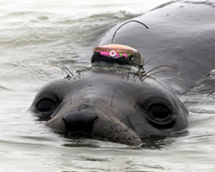
Female northern elephant seal with a Wildife Computers GPS tag on her head. The tags on her lower back are archival MK 9 tags that are used to record the diving behavior (Credit: Dr. Daniel Costa, UC Santa Cruz)

Animal Telemetry Network

Marine Biodiversity Observation Network (MBON)

Marine Biodiversity Observation Network (MBON)

Underwater Gliders

Underwater Gliders

HF Radar

HF Radar

Coastal and Ocean Modeling Testbed

Coastal and Ocean Modeling Testbed

Ocean Enterprise Studies

Ocean Enterprise Studies

Ocean Technology Transition

Ocean Technology Transition

Quality Assurance / Quality Control of Real Time Oceanographic Data

Quality Assurance / Quality Control of Real Time Oceanographic Data

Data Management & Cyberinfrastructure

Data Management & Cyberinfrastructure

Main Sections

  • Home
  • About
  • Communications
  • Data
  • IOOS In Action
  • Regions
  • Community

Useful Pages

  • NOAA
  • NOS

Our Social Ocean


Contact

U.S. Integrated Ocean Observing System
1315 East-West Highway 2nd Floor
Silver Spring, MD 20910

(240) 533-9444

Contact Us

Privacy Policy  |  Disclaimer  |  Contact Webmaster  |  Survey  |  Information Quality  |  FOIA  | Accessibility | Comment Policy

Website Owner: National Ocean Service  |  National Oceanic and Atmospheric Administration  |  Department of Commerce  |  USA.gov

indicates a link leaves the site. View our Link Disclaimer for more information.

OSZAR »